How to make an animated world map
- Pick the country. Search by its English name, its name in any of the 15 place-name languages, or its ISO code. The map frames it in the middle of the shot.
- Choose the neighbours. Every country that shares a land border is added for you. Remove the ones your script does not mention, move the rest into the order you say them, and tick “with above” to light two up at the same moment. You can also add any other country, such as an ally across the sea.
- Write the words on screen. A title and subtitle open the shot, and a short note can sit under the country name, for example its area or population.
- Set the timing. Drag the cuts in the segment bar under the preview, or load your voice-over and press Space each time the next country should appear.
- Export. 16:9 for YouTube, 9:16 for Shorts and Reels, 1:1 for posts. The MP4 is rendered on your computer, usually in under a minute.
The example: where is Mongolia?
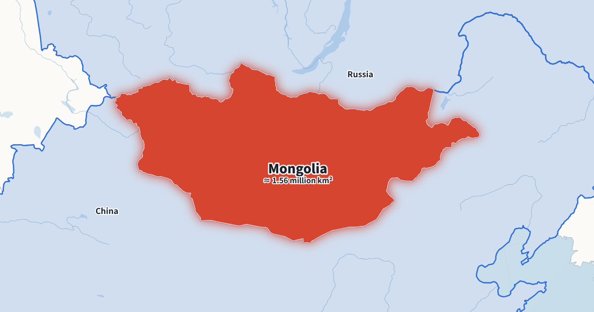
The animation above answers a question many geography videos start with. The globe turns, the camera settles over Central Asia, Mongolia lights up with its area (about 1.56 million km²) underneath, and then Russia and China appear in turn. The subtitle, “Landlocked between two giants”, gives the reason the shot exists.
Replace Mongolia with the country your video is about and the rest follows: the neighbours, the framing and the labels are worked out again. Everything you see in the example can be changed in the form on the left.
An animated world map that keeps your country in frame
Generic map tools zoom out whenever a big neighbour such as Russia, China or Brazil appears, and the country you are talking about ends up small in a corner. Here the camera is fitted to the country you picked and does not move after the fly-in. Neighbours show the part next to your country, and their names are placed inside the visible part of each one, away from your country's own label.
Very small countries, such as Liechtenstein or Singapore, are framed together with their surroundings instead of filling the screen, so viewers can see where they are. Wide countries such as Russia or Chile are framed by their whole extent, so nothing is cut off at the edges.
Two ways to open the shot
- Spin the globe and fly in. The globe turns, then the camera flies down to the country. Good for the first map of a video, when viewers need to know where on Earth they are.
- Country on screen from the start. No fly-in: the shot opens on the country. Good for the second or third map in the same video, when the globe would feel repetitive.
Map styles for an animated world map
Three base styles cover most channels: a light flat map, a dark news map with a glowing highlight, and a vintage paper map. On top of that you choose the main and second highlight colours, a sans or serif font, and whether borders, rivers and lakes are drawn.
Country names can be shown in English, Spanish, Portuguese, French, German, Italian, Turkish, Indonesian, Russian, Hindi, Arabic, Japanese, Korean, Chinese or Vietnamese. That lets a channel with dubbed versions export the same animated world map once per language. Save the combination as a channel style and every new map starts from it.
Where the neighbour list comes from
Neighbours are worked out from shared borders in Natural Earth's detailed 1:10 million data, so short borders are not missed (Spain and Andorra, Austria and Liechtenstein). The countries themselves are drawn from the 1:50 million data, which keeps the map clean at the scale of a country or region.
Islands such as Japan, Iceland or New Zealand have no land neighbours, so their list starts empty. Add the countries your script mentions, for example the nearest neighbours across the sea.
Ways to use an animated world map in a video
- Cold open: “This is Mongolia” over the fly-in, before the title card of your video.
- Context shot: light up the neighbours as you explain trade, borders, rivers or alliances.
- Series intro: one country per episode, all in the same channel style.
- Classroom: a short clip for a presentation on a country's geography.
For journeys between places, use the route animation; for armies and campaigns, the war map maker.
Writing the script for an animated world map
A country spotlight works best when the narration and the map say the same thing at the same moment. Write the sentence that introduces the country first (“Mongolia sits between two of the largest countries on Earth”), then one short clause per neighbour, in the order you want them to light up. Read it aloud once while tapping Space, and the map follows your voice.
If a neighbour is not part of the story, remove it rather than letting it light up silently; viewers notice when the map shows something the narration skips. If two neighbours belong to the same idea (“to the east, Kyrgyzstan and Tajikistan”), tick “with above” so they appear together.
Free animated world map export
Every animated world map exports as a 720p or 1080p MP4 at 30 fps for free, with a small watermark showing the site's address in a corner. You do not need an account; projects and channel styles are kept in your browser on this computer. A paid Creator plan without the watermark, with 60 fps, 4K and a transparent background, is planned.
Animated world map FAQ
Which borders does the map use?
Natural Earth's default borders, drawn at 1:50 million scale. Disputed areas follow Natural Earth's default point of view; the About page explains more.
Can I highlight a country with no land neighbours?
Yes. Islands such as Japan or Iceland simply start with an empty neighbour list; add any other country you want to show.
Can two countries light up at the same time?
Yes. Tick “with above” next to a neighbour and it appears together with the one before it.
Can I highlight several countries that are not neighbours?
Yes. Use “Add any other country” under the neighbour list. They light up in the order of the list, like neighbours.
Is there a satellite map?
Not yet. The current styles are vector maps drawn in your browser, which keeps exports fast and exact.
How long is the animation?
By default about 6 seconds plus 1 second per neighbour, so Mongolia with two neighbours runs 8 seconds. Drag any cut, or type a total length, to change it.
Can I show regions or states inside a country?
Not yet. The map works with countries; states and provinces are on the list of ideas.