How to make a map route animation
- Search the starting city and add each stop after it.
- Pick plane, train, car, boat or walk for each leg.
- Write a label for each stop, such as a day, a date or what happened there.
- Choose whether to tint the countries on the route and show the total distance.
- Adjust the timing in the segment bar, then export an MP4.
The example: an American Southwest road trip
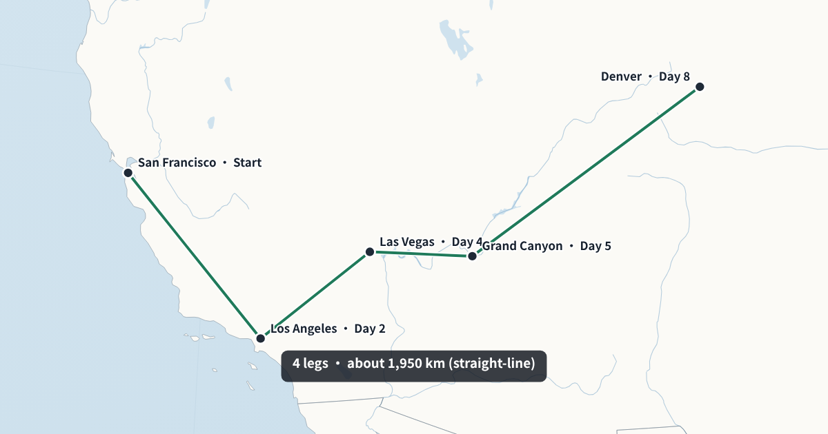
The map route animation above starts in San Francisco, drives down to Los Angeles, crosses the desert to Las Vegas, stops at the Grand Canyon and ends in Denver, with a label for the day of each stop. The camera follows each leg, then pulls back to show the whole route. Every city, label and colour in it can be changed.
Control every leg of the route animation
Each leg is a segment in the bar under the preview. Drag its edge to make it faster or slower; only that cut moves, and the leg after it absorbs the difference. Type a total length and the whole route rescales to it, exact to the frame. A 12-second route exports as exactly 360 frames at 30 fps.
Timing a map route animation to narration
Give long legs more time than short ones: by default each leg gets between 1.4 and 4 seconds depending on its distance. If you narrate the journey, load the voice-over and tap Space as you name each stop; the route then arrives at each city exactly when you say it. Leave a short hold at the end so viewers can read the full route.
Line styles for each mode of travel
- Plane: a dashed arc, so long flights read as flights rather than roads.
- Boat: long dashes over water.
- Walk: a dotted line for hikes and pilgrimages.
- Train and car: a solid line.
Mix them in one route: fly in, take the train, finish on foot. The line colour follows your main colour in the Style tab.
What people show with a map route animation
- Road trips, flight paths and cruise routes for travel videos (see the travel map animation page for vlog ideas).
- Explorers' voyages and migrations for history videos, such as a sea route along a coast or a pilgrimage across a country. For armies, campaign arrows fit better.
- Supply and delivery routes for a company video or a logistics explainer.
- Tours and relays: a band's tour dates, a cycling stage race or a torch relay.
How the route and distance are drawn
Legs are drawn as great-circle lines, the shortest path over the globe between two stops. On a long flight that path curves on the map, which is why a plane leg from Europe to North America bends north. The total distance at the end is the sum of those straight-line distances, not the road distance; say so in your narration if the difference matters.
Labels and titles on the route
Each stop has its own label, shown next to the city when the route arrives there: a day (“Day 4”), a date (“12 May”), or a word about what happened (“Base camp”). A title and subtitle open the animation and fade out shortly after the first leg starts, so the route itself has the screen. Keep labels short; the longest one sets how cluttered the final frame looks when every stop is visible at once.
Map route animation styles
Choose a light flat map for a clean, modern look, a dark news map when the route should glow, or a vintage paper map for historical journeys such as an explorer's voyage or a trade route. Set the main colour for the line and a second colour for highlights, choose a sans or serif font, and decide whether borders, rivers and lakes are drawn. Place names can be shown in 15 languages.
Save the look as a channel style, and every new route starts from it.
Using the route clip in your edit
The export is a standard MP4 (H.264) at 30 fps that opens in Premiere Pro, DaVinci Resolve, Final Cut and CapCut. Its length is exact to the frame, so if you timed it to your voice-over, it lines up when both start at the same point on the timeline. The clip has no audio, which keeps your sound mix in the editor.
For a long journey, consider several short route clips instead of one long one: one per day or per leg, each placed where the narration reaches it.
Free map route animation export
Exports at 720p and 1080p are free, with a small watermark showing the site's address in a corner. No account is needed and nothing is uploaded: the map and the video encoder run in your browser. A paid Creator plan without the watermark, with 60 fps, 4K and a transparent background, is planned for people who publish often.
Map route animation FAQ
Can I reorder stops after adding them?
Yes. Each stop has up and down buttons; the timing and camera are worked out again.
How many stops can I add?
As many as you like. Long routes simply take longer; set a total length to fit your video.
Can I change the line style?
Plane legs are dashed, boat legs long-dashed, walking legs dotted, and train and car legs solid. The colour follows your main colour.
Can I show the distance?
Yes. Tick “Show total distance at the end”. It is the straight-line distance between stops.
Can the route follow real roads?
No. Legs are smooth great-circle lines between stops. Add in-between stops if you want the line to pass a particular place.
Can I use a dark map?
Yes. Choose the dark news style or the vintage style in the Style tab.
Can I make a vertical version?
Yes. Switch to 9:16 for Shorts, Reels and TikTok, or 1:1 for posts; the camera re-frames the route.
Does the camera follow the route?
Yes. It frames each leg as it is drawn, then pulls back at the end to show the whole route.
Can I change the speed of one leg only?
Yes. Drag the cut at the end of that leg in the segment bar. Only that leg and the one after it change length; the rest of the route keeps its timing.
Does it work for a route inside one country?
Yes. The camera frames whatever area your stops cover, from a region of one country to a route across several continents.
Can I start the route with a title?
Yes. Write a title and subtitle in the form; they open the animation and fade out as the route begins.