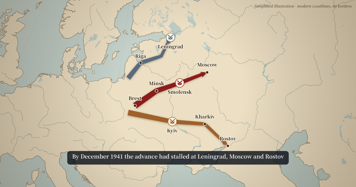
Operation Barbarossa in this WW2 map animation
- 22 June 1941: the invasion begins.
- 28 June: Minsk falls. 1 July: Riga is taken.
- July to September: Battle of Smolensk. 8 September: the siege of Leningrad begins.
- 19 September: Kyiv falls. 24 October: Kharkiv is taken. 21 November: Rostov is taken, and lost again a week later.
- 5 December: the Soviet counter-attack before Moscow.
The arrows are simplified: each army group is one line through a few cities, not a front line. That is usually what a narrated video needs: the direction and depth of each thrust, with the dates the narration mentions.
How to make a WW2 map animation
- Rename or recolour each army group in the Campaign arrows form.
- Change the dates in the captions, or add places where your narration pauses.
- Tick “Battle marker” for the battles you talk about.
- Set the arrow widths if you want to show strength, then write the closing caption.
- Load your voice-over and tap Space at the start of each sentence, then export.
Other WW2 map animations you can make
Swap the cities and dates to show another theatre. Some starting points:
- Poland, September 1939: arrows from the west, north and south converging on Warsaw.
- France, May–June 1940: the thrust through the Ardennes to the Channel coast, then the turn south to Paris.
- North Africa, 1940–1943: advances and retreats along the coast road between Libya and Egypt, with El Alamein as a battle marker.
- The Pacific, 1942–1945: an island-hopping route from Guadalcanal towards Okinawa as a series of short arrows.
- Normandy to the Rhine, 1944–1945: the Allied advance from the D-Day beaches across France.
For “where is this country” segments in the same video, use the country spotlight; for a convoy or a flight path, the route animation.
Styling a WW2 map animation
Many WW2 channels keep one colour per side for the whole series, for example a red family for one side and a blue family for the other, with a different shade per army group. Save your colours, font and map style as a channel style so every episode matches.
The vintage style suits archive-heavy videos; the dark news style suits a modern documentary look. Modern borders are hidden in the example because they differ from 1941; the corner note says so on screen. Turn borders on if you prefer a present-day reference map.
What a WW2 map animation here cannot do yet
- Moving front lines. Arrows show thrusts; a front line that moves day by day is planned.
- Unit symbols. Use names, labels and battle markers for now.
- Occupation zones and 1939–1945 borders. Historical boundaries need licensed data; for now, use the corner note to explain what is shown.
If one of these is what your video needs, the email box in the export dialog is the best way to tell us.
Colours and sides on a WW2 map
Pick one colour per side and keep it for the whole series, then vary the shade for each army group or fleet. Give every arrow a name in the form, such as “Army Group Centre” or “Eighth Army”; when an arrow has no date caption at a point, its name is shown as the caption instead. That keeps viewers oriented when three arrows move one after another.
Arrow width can show strength, but WW2 numbers are often disputed. If you use width, use the same scale for both sides and say in the corner note what the width stands for.
Writing captions for a WW2 map animation
A caption is read in about two seconds while the arrow moves, so keep it to a date and an event: “8 Sept 1941 · Siege of Leningrad begins”. Use the same date format in every caption of the video; mixing “8 September” and “09/08” makes viewers stop and think. Spell place names the way your narration says them; if your script says Kiev and the map says Kyiv, pick one and use it in both.
The closing caption is the place for the outcome or a figure. Keep it to one line if you can, and leave it on screen for at least two seconds.
Checking the facts before you publish
WW2 audiences notice wrong dates. The example's dates follow standard accounts, but your video is your responsibility: check every date and place against at least one source you trust, such as a published history of the campaign or an official war history, before you export. Where historians disagree about a date, the caption is a good place to say “c.” or give a range.
Arrows simplify. If your narration describes encirclements or front lines in detail, say on screen that the arrows show the main thrusts only. The corner note field is there for exactly that.
A WW2 map animation for school projects
Students can make one for a presentation without installing software or making an account. Open the page, edit the example, export an MP4 and drop it into slides. Because nothing is uploaded, it also works on shared school computers; projects are kept only in that browser. The free export carries a small watermark with the site's address.
WW2 map animation FAQ
Where do the city names come from?
From Natural Earth, in their modern form. For a period name, such as Stalingrad for today's Volgograd, write it in the date caption or untick the label and add your own text in your editor.
Can it show moving front lines?
Not yet. Arrows show the direction and depth of an advance; a front line that moves over time is planned.
Can I add unit symbols?
Not yet. Use labels and battle markers for now.
Is it suitable for school projects?
Yes. It is free, runs in the browser and exports a normal MP4.
Can I make a vertical version for Shorts?
Yes. Switch to 9:16 at the top of the editor; the camera re-frames the same arrows for the tall format.
Can I put two theatres in one video?
Make one animation per theatre and place them one after the other in your editor. They share the same channel style if you saved one.
Can I change the arrow colours to match my channel?
Yes. Every arrow has its own colour picker. Save your colours as a channel style to reuse them.
How long is the Barbarossa example?
About 19 seconds: an opening, around two seconds for each city an army group reaches, and a hold at the end. Drag the cuts or type a total length to change it.