How to make a travel map animation
- Add your first stop. Search the city where the trip starts.
- Add the next stops. Keep going in the order you travelled; move or remove stops at any time.
- Choose how you got there. Plane, train, car, boat or walk for each leg.
- Label the stops. “Day 1–3”, a date, or a word about the place.
- Preview and export. Press Play, adjust the timing if you want, then export an MP4 in the shape your platform needs.
The example: 10 days in Europe
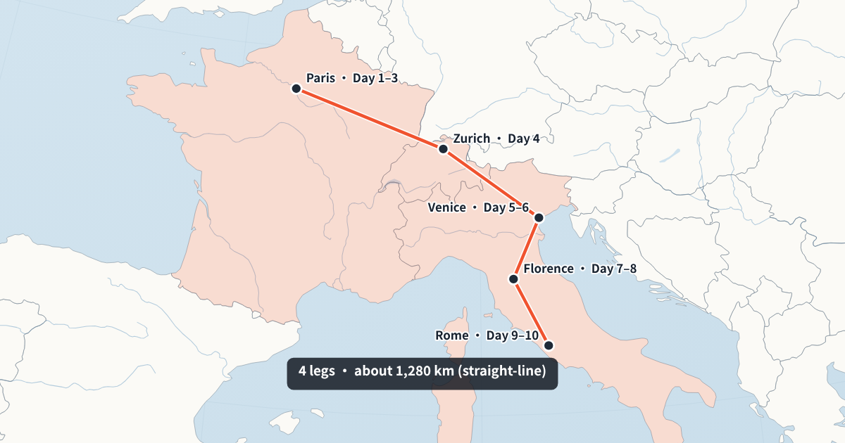
The travel map animation above flies into Paris for days 1 to 3, then goes by train to Zurich, Venice, Florence and Rome, with a label for the days spent in each city. Each leg gets a length that matches its distance, the countries on the way are tinted, and the last caption gives the total distance. Replace the cities with your own and the camera, labels and timing are worked out again.
Travel map animation for Reels, TikTok and Shorts
Switch to 9:16 at the top of the editor and the same trip is re-framed for a tall screen, not cropped. The camera follows each leg and ends on the whole route. Short-video apps put buttons and captions over the edges of the screen, so the route keeps a margin on every side, leaves the bottom fifth clear and puts your title at the top.
Use 16:9 for a YouTube vlog and 1:1 for a feed post. All three come from the same project, so you set up the trip once.
Travel map animation ideas for vlogs
- Trip intro: show the whole route in the first five seconds, then cut to your footage.
- Chapter breaks: make one short clip per leg and drop it in before each city.
- Countries visited: tick “Colour the countries visited” for a year-in-review or a backpacking recap.
- Long-haul flights: a plane leg across continents shows the globe turning under the flight path.
- Itinerary posts: a 1:1 clip with day labels that shows followers the plan before you go.
Plane, train, car, boat or walking
Each leg's line shows how you travelled. Plane legs are dashed, boat legs long-dashed, walking legs dotted, and train and car legs solid. The colour follows your main colour, which you choose in the Style tab together with the map style (light, dark or vintage), the font and the language of place names.
Legs are drawn as smooth great-circle lines between stops. That is the usual look for travel intros and keeps the map readable; the line does not follow the exact road or rail line.
Tips for a travel map that reads at a glance
- Keep labels short. “Day 4” reads faster than a sentence; save the story for your voice-over.
- Merge small hops. A day trip from Florence to Pisa can be left out of a two-week route.
- Give the end a hold. The last frame shows the whole route; leave it on screen long enough to read.
- Match your colours to your thumbnails and save them as a channel style for the next trip.
For a route that is not a holiday, such as a delivery route or an explorer's voyage, see the map route animation page.
Timing each leg of the trip
Each leg gets a length that matches its distance, between 1.4 and 4 seconds, so a flight across an ocean takes longer than a short train ride. Drag any cut in the segment bar to change one leg without touching the others, or load your voice-over and tap Space as you name each city.
Free travel map animation, no app to install
The editor runs in a recent Chrome or Edge on your laptop or desktop. There is no app to install and no account to create; your trips are kept in your browser on that computer. Exports are free at 720p and 1080p, 30 fps, with a small watermark showing the site's address in a corner.
Making and exporting works best on a computer. You can open the editor on a phone to check a route, then export on a laptop and send the MP4 to your phone for posting.
What makes this travel map animation different
Phone apps that animate a trip are quick, but they usually give each leg the same length and export one shape. Here every leg has its own time, which you can set by tapping along your voice-over, and the same trip exports as 16:9, 9:16 and 1:1. The camera re-frames for each shape instead of cropping, so a route across Europe still fits a tall Reel.
You also control the look: light, dark or vintage maps, your own colours and font, and place names in 15 languages. Save that as a style and every trip you post looks like it belongs to the same account.
Putting the trip map into your vlog
Export the clip and drag it onto your editing timeline in CapCut, Premiere Pro, DaVinci Resolve or Final Cut. The MP4 is silent, so your music and voice carry over it. A common pattern is a full-route clip at the start, a short single-leg clip before each new city, and the full route again at the end with the total distance.
Travel map animation FAQ
Can I import a GPX track?
Not yet. Add the stops by city; GPX import is planned.
Does the route follow real roads or rail lines?
No. Legs are drawn as smooth great-circle lines between stops, which is the usual look for travel intros.
Can I find small towns?
The city search covers about 7,300 cities and towns worldwide. If a village is missing, pick the nearest town and label it with the village's name.
Is it free?
Yes. It exports as a 720p or 1080p MP4 for free, with a small watermark in the corner.
Can I add photos to the stops?
Not in the map itself. Export the map and place your photos and clips around it in your video editor.
Does it show the total distance?
Yes. Tick “Show total distance at the end”. It is the straight-line distance between your stops.
Can I make one clip per city?
Yes. Make the full route first, then remove stops to export a short clip of a single leg. Save the style so every clip matches.
Which map styles are there?
A light flat map, a dark map with a glowing route and a vintage paper map. Colours, font and the language of place names are yours to choose.